
Twelve Capital Event Update: Hurricane Beryl
5 July 2024Event Update – As Hurricane Beryl continues its path through Yucatan, our current central scenario is of no losses to Cat Bonds.
5 July 2024 – 3.00pm (CEST)
Development and landfall
After its first landfall in the Grenadine Islands (Carriacou, on 1 July at approximately 11am local time), Major Hurricane Beryl continued to strengthen as it headed across the Caribbean Sea, reaching Category 5. By the time the storm reached Jamaica, Beryl was still a Category 4 storm and despite not making a direct landfall, significant damage has been reported and many homes still remain without power.
Following some weakening, mostly a reflection of strong wind shear, Beryl today made landfall at approximately 6am local time in the Yucatán peninsula, Mexico, as a Category 2 hurricane. Strong winds, rainfall and storm surge has been experienced in popular tourist locations, such as Tulum.
Current models predict the storm to cross Yucatán and further weaken. It is likely to continue as a weak hurricane or tropical storm, however there remains time for Beryl to intensify before any future landfall.
Potential exposure for Cat Bonds investors
As previously stated in our last Event Update, despite its elevated strength, hurricane Beryl’s path across the Caribbean Islands and Yucatán is not expected to generate significant losses for Cat Bond investors.
The IBRD CAR Jamaica bond, appears not to be triggered at the time of writing. It should be noted that the NHC reported central pressure estimates and coordinates of the storm are incredibly close to triggering the Cat Bond, so any final data revisions will be monitored closely.
As the storm made landfall in the Yucatán peninsula, the main Cat Bond to monitor is the IBRD Mexico 2024 Class-C notes, which given current NHC central pressure estimates, is not at risk from this landfall.
However, as the map shows below, there will likely be a future landfall after the storm makes it through the Gulf of Mexico, with both Northern Mexico and Texas at potential risk from a hurricane landfall. There is significant model uncertainty with respect to both Beryl’s intensity and location as it moves through the Gulf of Mexico, so we will continue to monitor closely.
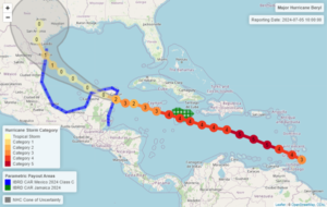
Figure 1: Observed and future forecasted storm track of Hurricane Beryl, overlaid with the parametric exposure to both IBRD Jamaica and Mexico transactions. Source: National Hurricane Center (NHC). As at 5 July 2024.
Other Activity
There are currently no other systems in the Atlantic and no tropical cyclone formation is expected during the next 7 days.
In the Pacific, Tropical Storm Aletta has become the first named storm of the season, in what has been the slowest start to the season on record (approximately last 60 years). Current models forecast Aletta to weaken and remain in the Pacific Ocean, causing no threat of landfall.
Twelve Capital continues to closely monitor relevant potential and actual catastrophe events and will issue specific updates on new major events which will occur.