
Twelve Capital Event Update
27 September 2024Situation in the Atlantic
The Atlantic hurricane season is past its midpoint, and this past week has seen an uptick in activity. Currently, there are two active systems: Helene and Issac. Hurricane Helene made landfall as a Category 4 storm in the early hours of Friday, 27 September, while Issac is in the Atlantic and poses no threat to the US. In addition, there are two further areas of potential storm development, one in the main development region and one in the Caribbean Sea.
Hurricane Helene
At approximately 03:00 UTC on 27 September, Hurricane Helene made landfall away from large inhabited areas in the Big Bend region of Florida, as a Category 4 Storm. It became the second Major Hurricane of the 2024 Atlantic season, after Hurricane Beryl. In the final hours of its approach, Helene underwent intensification with maximum sustained wind speeds reaching 140mph, but the storm also moved slightly eastwards away from its initially forecasted paths, and importantly away from Florida’s capital city Tallahassee, which once seemed to be directly under the path of Helene.
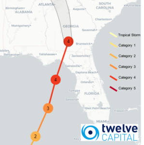
FIGURE 1 – Path of Hurricane Helene.
Although widespread damages have already been reported, with significant storm surge along the west coast of Florida, initial estimates suggest losses below the attachment points of per-occurrence Cat Bonds. Over the course of the next few days it will become clearer in terms of the extent of the damage. Currently, Helene is still heading further inland and causing impacts in Georgia, Alabama and South Carolina. The area where Helene made landfall is not densely populated, and given the eastward movement of the storm away from Tallahasee, this looks to have reduced the possible total industry impact. Whilst we do not expect any direct impact from this event on our positions, aggregate erosion will be further increased across applicable bonds.
Please note: Twelve Capital will issue a more in depth event analysis in the coming days once the event has developed further.
Hurricane John
In the Pacific, Hurricane John formed off of the coast of Mexico before going through rapid intensification and making landfall near Aculpoco as a Category 3 hurricane on 23 September. This is a similar pattern and landfall location we experienced last year with Hurricane Otis. Unlike Otis, the Mexico IBRD Notes covering Mexico Pacific Hurricanes are not expected to trigger, given the central pressure estimates for the system are well below the bond’s attachment parameters. Hurricane John is still ongoing and looks set to make second landfall further up the coast after going back out into the ocean and strengthening, but the severity will be much lower.
Twelve Capital continues to closely monitor relevant potential and actual catastrophe events and will issue specific updates on new major events that occur.
Please feel free to contact us with any questions.